 The Kentish village of Otford lies at the head of the Darent Valley, which cuts through the chalk Downs on its way to join the River Thames at Dartford some twenty miles downstream from London. It is situated at a river crossing of at least two prehistoric long-distance trackways, which followed the scarp of the North Downs linking Salisbury Plain and Stonehenge with the Channel crossings to continental Europe.
Flint implements found locally indicate the area has been inhabited for at least twenty thousand years, while traces of settlement have been found in the Combe (a dry valley north-east of the station) in the form of Peterborough Ware pottery fragments and a hearth some four thousand years old.
A Middle-Bronze Age cremation urn found below a round barrow on Otford Mount, dating from about 1450 BC, sheltered the remains of the earliest identifiable resident of the area. The Iron Age is represented by a hillfort, also on the Mount, and recently discovered evidence of occupation near the station.
In Roman times there were at least three substantial villa-farmsteads, a native settlement and a cremation cemetery. In the late fourth century it seems to have had a Christian community similar to that at Lullingstone Villa some four miles to the north, however, no trace of this early settlement’s name survives.
 Roman administration ceased to function in the early fifth century, and the villas were either destroyed or fell into decay. Subsequent Germanic immigrants seem to have dominated the district, and evidence of their presence is to be found on the west bank of the river where a cremation cemetery existed, and at the Anglo-Saxon burial ground on Polhill. A newly discovered abattoir site east of the railway suggests widespread occupation; however, it is likely that the nucleus of settlement, even then, lay along the main trackway east of the ford (today’s High Street). The village’s name may commemorate an early settler from this era – Otta – who presumably had property near the ford over the river Darent.
The first mention of ‘Otford’ is in the Anglo-Saxon Chronicle, when a battle was fought here in about the year 775 between Offa, King of Mercia and Egbert, the Kentish King. Egbert’s victory at ‘Ottanford’, despite overwhelming odds, ensured continued independence for the Cantware against a formidable foe who had hitherto swept all before them. Indeed, the battle at Otford must stand as the Kingdom of Kent’s ‘finest hour’.
 In 821 King Cenulf gave land to the Archbishop of Canterbury, suggesting that there was already a royal estate here. Further gifts followed, and over the next seven hundred years Otford became the administrative centre of estates owned by the Archbishop as far apart as the Thames Estuary and the Sussex border – known as the ‘Honour of Otford’. By tradition the earliest buildings on the site were wooden, but were rebuilt in stone by Lanfranc, the first Norman archbishop. The palace’s timber chapel survived until the 1290s when it was rebuilt in stone by Archbishop Peckham – to match the magnificent hall raised earlier by Boniface, ‘since he could not believe that he had intended to be more nobly lodged than the Son of God’.
St.Thomas Becket regarded Otford as his favourite residence and he gave his name to the medieval cistern, Becket’s Well. Its water continues to feed the Darent to this day. A charming local legend asserts that the saint struck the ground with his staff (like Moses) and a miracle-working spring issued forth!
During interregnums – the period between the death (or exile) of an archbishop and the appointment of his successor – the property reverted to the Crown. In 1348, the year of the Black Death, Archbishop Stratford died and King Edward III celebrated Christmas at Otford with his court where, despite prevailing events, the festivities were remarkably carefree!
 The archbishop’s manor house became one of the most magnificent buildings in medieval England – a home to 57 archbishops, who welcomed and entertained most of the kings and queens of England. They also played host to both English and foreign ecclesiastical dignitaries. As befitted the dignity of the Premier See, archaeological investigations confirm that regular enlargement of the building took place within the moated manor site. In fact, the moat was re-cut on at least three separate occasions to provide room for expansion.
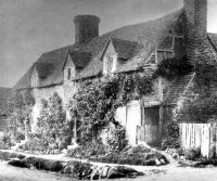
Around the year 1510, Archbishop William Warham rebuilt and enlarged the structure of the palace, adding a huge northern courtyard and gatehouse range known as the Inner Court, and henceforth the manor became known as ‘Otford Palace’. In 1537, it became a royal palace when Archbishop Thomas Cranmer was compelled to surrender it to King Henry VIII who stayed there and spent money on its maintenance, but alas, after Henry’s death in 1547, much of the lead was looted from its roofs, leading to the rapid decay of the interior fabric. Queen Elizabeth refused to spend money on repairs, and by 1600 had washed her hands of the palace completely.
Ambitious plans by Sir Robert Sidney of Penshurst to construct a new mansion did not materialise and, over the next two centuries, the old palace was plundered for its building stone and bricks – leaving just the shell of one Tudor tower, part of the north gallery and the ground floor of the gatehouse to hint at its former splendour. Fragments of the moat wall found in Bubblestone Road bear further witness to its impressive size.
Throughout the medieval period the village grew alongside the Manor, and most of its inhabitants served the archbishop. The wooden parish church dedicated to St. Bartholomew was replaced with one of stone by c1050; the tower was added about a hundred years later, and it was enlarged to its present size by the addition of the south aisle early in Tudor times, but suffered fire damage in the 1630s necessitating the roof’s replacement.
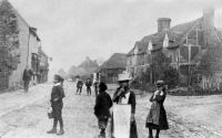
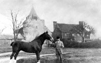
The village grew along the road leading from the Church to the ford. It was known as ‘The Strete’ until the end of the nineteenth century, and the ‘Town’ is described in a survey of 1541. It ‘standith northe west side of [the Palace] in one strete partly buylded on both sides with some fayre houses which contayneth in lengh VIII hundred fete. Also, the Ryver is current through the said Towne whereuppon standeth a water mill ...’ a description which would adequately describe Otford for at least another three hundred years.
 The spring-fed village pond was probably constructed in Anglo-Saxon times, and until the early twentieth century (when it was culverted) it discharged its overflow down a streambed on the northern side of the High Street to trickle into the nearby mill stream.
Although Otford was predominantly agricultural, there were also chalk quarrys and brickfields (which continued until the twentieth century). Two turnpike roads traversed the parish in the late eighteenth century – the London to Hastings road through Dunton Green, and the Dartford to Sevenoaks road along the Darent Valley. The coming of the railway between Swanley and Sevenoaks in 1862 had a limited impact upon the village until 1882 when Otford Station was built which enabled people to commute to London. Apart from a few new houses there was little change until World War I, when a Lancashire territorial army camp was established in the village.
 Twitton is an ancient hamlet on the western side of the valley, at the edge of the parish, and it shares with Shoreham a boundary that runs down the centre of the road. Nearer to Sevenoaks, the village of Dunton Green gained independence from Otford and became a separate parish in 1908 – having expanded rapidly, following the arrival of the London to Sevenoaks railway in 1868.
The 1920s saw the start of great changes in the village, with housing estates springing up near the station, and ribbon development flourished until the outbreak of war. The Battle of Britain was fought in the skies overhead, and Otford suffered some damage and casualties from bombing.
 After the war the value of the landscape was recognised and Otford was included in the Metropolitan Green Belt, while additional controls were imposed to limit damage to the local environment and ecology. Inevitably, additional building took place throughout the remainder of the twentieth century, but with planning controls, most developments have, thus far, integrated reasonably well into the landscape.
Otford continues its Christian tradition (which archaeology may yet prove to be among the longest-established in the country) with four churches of different denominations serving the needs of the community. Education in the village is provided by a state junior school (established in 1872) and two preparatory schools. Traditional shops continued to serve the village until the 1980s when most were forced out of business by the coming of out-of-town ‘super-stores’. Fortunately not all shops have disappeared, but they have been replaced by retailers catering for the diverse tastes of the villagers and visitors of today. Over one hundred businesses operate in the village and Vestry Estate, providing local employment.
Despite the pressures placed upon the village (in particular, the blight of speculative development) its inhabitants and Parish Council ensure Otford retains a caring and thriving community spirit, with numerous activities for all ages. This led to Otford being awarded the title, ‘Village of the Year for South and South East England’ in 2002-2003.
